
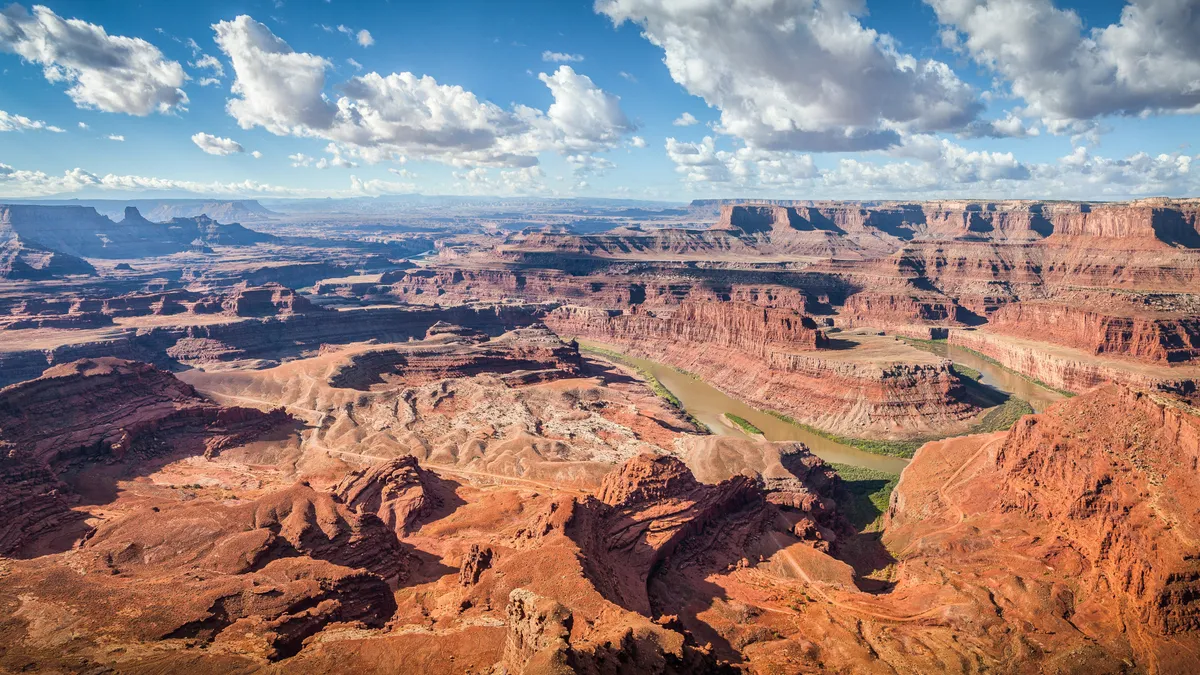
Canyonlands National Park is a geological mecca for rugged desert adventure. South of Moab, Canyonlands holds the distinction of being the largest National Park in Utah, preserving 337,598 acres of canyons, mesas, arches, spires, buttes and fins. The best hikes in Canyonlands National Park deliver dramatic desert landscapes, stunning spires and perfectly preserved rock art.
Less than ten miles from Arches National Park, Canyonlands is so big that it’s divided into four sections by the Colorado and the Green River: Island in the Sky, The Needles, The Maze and Horseshoe Canyon. Each of the these districts has a distinct flavor. Of the four, Island in the Sky is the most accessible, while The Needles offers a bit more of a backcountry experience and The Maze is extremely remote. Horseshoe Canyon is a day-use area famous for its Indigenous rock art. The four sections are not directly linked by road and traveling between them takes several hours by car so you can either pick one section to explore, or plan to have more than a couple of days here.
When you’re planning a visit to Canyonlands, you don’t want to just sling your hiking boots in your car and head out unprepared. Make sure to read our articles on desert hiking and desert camping if you’re planning on backpacking and get yourself a good map of the area since you can’t always rely on GPS in this rugged area.

For this article, we’ve picked our favorite hikes in Island in the Sky and the Needles, and outlined how to access the best rock art in Horseshoe Canyon. The Maze requires backcountry survival gear and skill for self-rescue so we haven’t included it in our roundup, but we’re sure you'll find all the adventure you need in these great hikes.
Best hikes in Canyonlands National Park: Island in the Sky
Island in the Sky in the northern section of the Park is the most accessible area of the park with paved roads and well-marked trails. Nestled high on the mesa between the Colorado and the Green River, the hiking here delivers truly spectacular views of the area.
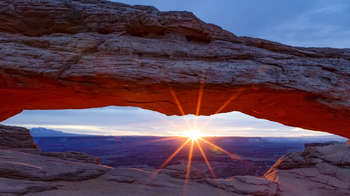
Mesa Arch

Distance: 0.7 miles
Difficulty: Easy
Mesa Arch is perched on the edge of a cliff and offers spectacular views of the park in all directions. This trail is accessible for kids so it’s great for hiking with the whole family.
This short, easy trail takes you across slickrock to the arch which sits atop a 500ft cliff overlooking Buck Canyon.
Park at the Mesa Arch trailhead and follow the signs to join the trail. The arch is classified as a pothole arch because it was formed by sitting water that slowly eroded the sandstone rock. Through the arch, you’ll be able to see the snow-capped La Sal Mountains in the distance, and Washer Woman Arch off to the left. The best time to do this hike is at sunrise or sunset.
Grand Viewpoint
Distance: 1.8 miles
Difficulty: Easy
For unparalleled views, look no further than Grand View Point Trail. Stand at the viewpoint over 6,000ft above sea level and feast your eyes upon the deep rugged canyons cut by the Colorado and Green River spread out before you that seem otherworldly.
Pick up the trail at the parking area at the very end of Grand Point View Drive and after only 100 years of easy paved trail you’ll arrive at the first viewpoint. After this, the trail takes you down some steep rocky steps and continues to the very edge of the Island in the Sky Mesa where you can take in the views of Monument Basin before continuing on to the end for sweeping views of Canyonlands.
Upheaval Dome Overlook

Distance: 1.3 miles
Difficulty: Moderate
Upheaval Dome is perhaps the most curious geological in a park full of curious geological features. Some think this massive crater is the result of a meteor impact while others believe it is a salt dome. Either way, at three miles in diameter, the best way to view it is from up high. This hike takes up stone steps to the rim then along the rim to two key lookout points. The second point is reached by following rock cairns.
From the Island in the Sky Visitor Center, drive south for 6.5 miles. Turn right onto Upheaval Dome Road and drive another 5 miles to the end of the road.
Syncline Loop

Distance: 8.6 miles
Difficulty: Challenging
This challenging loop can be done as a long day hike or an overnight backpacking trip. It takes you along the canyons around Upheaval Dome, but doesn’t actually offer views of the feature itself. This hike is extreme desert hiking, meaning that it is very primitive, difficult to follow and offers little shade along the way. It’s an excellent adventure chock full of geological wonders, but you should go armed with lots of water, a map and the best GPS watch.
The trail starts from the Upheaval Dome trailhead, and if you hike the loop clockwise it will be less strenuous.
Best hikes in Canyonlands National Park: The Needles
In the southwest portion of the Park, the Needles is famous for its abundance of breathtaking colorful spires. The hiking here is a bit more primitive, so make sure you get a map of the area and have a plan for your hikes.
Lost Canyon

Distance: 8.2 miles
Difficulty: Moderate
Spectacular Lost Canyon often has a flowing stream in the springtime and that makes the vegetation here a little more diverse and the colors even more vivid. This loop makes a long day hike or a great overnight adventure – there are three campsites in the canyon. After hiking through Lost Canyon for two miles, take the sharp right into a narrow gorge for a half mile. Climb a steep chute via an NPS ladder to a slickrock ledge then soon drop into Squaw Canyon. Turn right at the next junction and after a couple of miles, hook back up with Peekaboo trail which returns you to the trailhead.
From The Needles entrance station, drive west for 2.7 miles and turn left into Squaw Flat campground. You can go either way at the fork, but taking the road on the left and parking at that trailhead saves you a little time on foot to the backcountry.
Druid Arch

Distance: 10.4 miles
Difficulty: Moderate
Druid Arch is a long day hike, but still one of the most popular hikes in the Park as the best way to take in what makes The Needles so special. This hike takes you via Elephant Canyon to a stunning rock arch that is quite unique and looks a bit like Stonehenge. To get there, you’ll travel on slickrock, between rock formations, across narrows and up ladders and short scrambles. At the first junction after 1.5 miles, bear right to Chesler park. After dropping into Elephant Canyon, go straight rather than left into Squaw Canyon and head towards the arch. Return the same way you came.
From The Needles entrance station, drive west for 2.7 miles and turn left into Squaw Flat campground then take a right onto the Elephant Hill Access Road and drive three miles to the trailhead.
Slickrock Foot Trail

Distance: 2.4 miles
Difficulty: Moderate
Rather than descending into a canyon bottom, this loop stays up high and offers splendid views of the northeastern portion of the Park. It’s also fairly well-marked so it’s more accessible than many other trails in The Needles. Take the hike counterclockwise and enjoy panoramic views of the surrounding mountain ranges as well as the Needles themselves.
Find the Slickrock Foot Trail Parking Area on the right 6.4 miles from the Needles entrance station.
Best hikes in Canyonlands National Park: Horseshoe Canyon
Horseshoe Canyon is a deep canyon with sheer sandstone walls that is located northwest of the main Park area and is famous for its stunning collection of indigenous rock art depicting life-sized figures.
The Great Gallery

Distance: 7 miles
Difficulty: Challenging
It’s defiintely worth carving out a day in your itinerary to visit The Great Gallery, an impressive panel of well preserved indigenous rock art that dates back to between 9000-7000 BCE. However, to get to the Gallery requires a certain amount of commitment in the form of dropping into the canyon for a seven mile round trip slog across the sandy bottom. Your day of course ends with a climb back out of the canyon. This hike is truly a once-in-a-lifetime experience as the canyon is spectacular and the art is some of the most significant in the country. The Great Gallery itself contains some 20 images but there are other, smaller galleries along the way.
You’ll want a map (don’t rely on GPS) to get you to the Hans Flat Ranger Station, which is about 2.5 hours drive from Moab and 1.5 from Green River. From the Ranger Station, a four-wheel-drive road leads to the east rim.

