
With rugged canyons and beguiling rock formations, the best hikes in Moab, Utah feel out of this world. While we often associate hiking out west with the alpine forests and granite peaks of Colorado and California, the slick rock trails and red sandstone spires of Utah will make you feel like you’ve landed on another planet.
In an experience like no other, you can traverse magnificent buttes and mesas and circle striking pinnacles here in a desert landscape that has been sculpted over millennia by the slow power of ancient oceans, rain, wind and the winding paths of the Colorado and Green River.
Moab is a small city on the Colorado River in eastern Utah, less than two hours west of Grand Junction and about three and a half hours southeast of Salt Lake City. Flanked by Arches National Park to the north, home to more than 2,000 rock arches, and Dead Horse Canyon State Park and Canyonlands National Park to the southwest, Utah’s stunning desert landscape offers a truly iconic mix of geological and human history. The hikes here will take you through jaw-dropping rock arches, spires and fins, dramatic canyons and a plethora of ancient Native American rock art.


With its desert climate and little protection from the sun to be found on most trails, the best time to visit Moab is in the spring or the autumn. The entire region fills up with tourists from around the world as well as folk from nearby ski towns celebrating the end of a long winter at this time of year, but it’s by far the best and safest time to hike and avoid the dangerous summer heat. You should plan to start your hikes early to beat the heat and the crowds, and dress in layers as the desert is susceptible to wild temperature swings. Fill up your hydration pack with water and despite the seemingly even rock trails, you’ll want to pack a pair of the best hiking shoes or boots as the terrain can be slick.
Without further ado, here’s our list of the best hikes in Moab, Utah offering otherworldly adventure:
Delicate Arch Trail

Distance: 3 miles
Difficulty: Moderate
The hike to Delicate Arch easily tops the to-do list for hikers visiting Moab, and it’s no surprise. As one of the most famous geological formations in the world, Delicate Arch has become the unofficial state symbol of Utah and even made it onto a commemorative quarter.
This free-standing sandstone arch is the largest in Arches National Park standing 46ft high and 32ft wide and you can’t see it from the road so you’ll have to get your hiking boots on. Park at the trailhead for Wolfe Ranch and take the smooth, red slickrock trail uphill at a steady pace passing some smaller stone arches and a wall of Ute Indian petroglyphs on the way as well as two good viewpoints of the arch. The real event however is getting up close to the arch so it’s worth going all the way.
Mesa Arch Trail
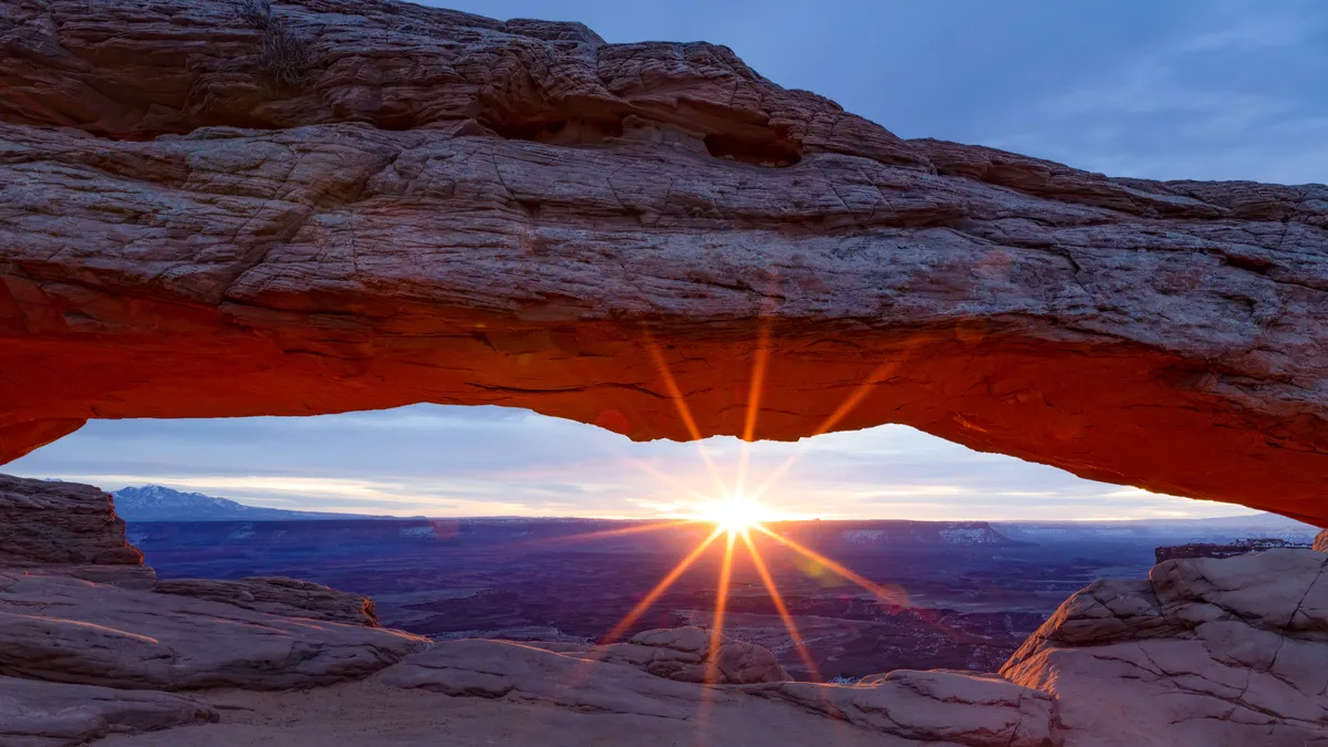
Distance: 0.7 miles
Difficulty: Easy
Over in Canyonlands National Park, Mesa Arch is perched on the edge of a cliff and offers spectacular views of the park in all directions. This trail is accessible for kids so it’s great for hiking with the whole family.
This short, easy trail takes you across slickrock to the arch which sits atop a 500ft cliff overlooking Buck Canyon. Park at the Mesa Arch trailhead and follow the signs to join the trail. The arch is classified as a pothole arch because it was formed by sitting water that slowly eroded the sandstone rock. Through the arch, you’ll be able to see the snow-capped La Sal Mountains in the distance, and Washer Woman Arch off to the left. The best time to do this hike is at sunrise or sunset.
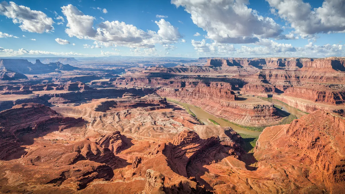
Dead Horse Rim Loop Trail

Distance: 5 miles
Difficulty: Moderate
Dead Horse Rim Loop Trail is located in Dead Horse Point State Park which sits 2,000 ft high on the rim of the Colorado River Canyon. It provides stunning views of the whole Moab area and tends to be quieter than some of the other local trails.
Sometimes referred to as the ‘Grand Canyon’ of Utah, this trail takes you through high desert landscape and treats you to panoramic views across Canyonlands to the La Sal Mountains and down to the Colorado River. This hike is actually a combination of the East and West Rim routes that circle around the desert plateau. Park at the visitor center and pick up either trail – there are several overlooks along the way that are worth the diversion if you can spare the extra time and distance.
Landscape Arch

Distance: 1.9 miles
Difficulty: Easy
This hike features an easy paved trail to the biggest arch on the planet. Chunks of rock have broken off the arch over the last 100 years, some as large as cars, leaving the arch itself looking precariously thin, increasing the sense of urgency around seeing this arch soon lest it collapses completely. Park at the trailhead for Devil’s Garden Trail in Arches National Park. The arch is located at the end of Devil’s Garden Trail and the walk there takes you through a playground of arches, spires, and fins which are narrow rock walls that eventually erode and give way to the formation of arches like Landscape Arch.
Grand View Point Trail
Distance: 1.8 miles
Difficulty: Easy
For unparalleled views over Canyonlands National Park, look no further than Grand View Point Trail. Stand at the viewpoint over 6,000ft above sea level and feast your eyes upon the deep rugged canyons cut by the Colorado and Green River spread out before you that seem otherworldly.
Pick up the trail at the parking area at the very end of Grand Point View Drive and after only 100 years of easy paved trail you’ll arrive at the first viewpoint. After this, the trail takes you down some steep rocky steps and continues to the very edge of the Island in the Sky Mesa where you can take in the views of Monument Basin before continuing on to the end for sweeping views of Canyonlands.
Hidden Valley Trail

Distance: 6 miles
Difficulty: Difficult
The Hidden Valley Trail follows an ancient path used by Native Americans for the past two thousand years. This trail begins with a steep climb to a hidden valley in the cliffs south of Moab where you will find memorable vistas and Ute Indian rock art.
Find the trailhead at the south side of the dirt parking area on the south side of Spanish Valley. The initial climb is steep, gaining almost 600ft in just over half a mile before levelling out into a dirt trail when you reach the valley. The shallow, wide valley is framed by sandstone cliffs capped with rounded Navajo Sandstone domes. The trail takes you to the western end of the valley and another short climb leads you to a saddle where you’ll find great views of Hidden Valley, cliffs, rock fins, and domes. Turn around here or follow the trail that goes west along a cliff band then scrambles up to the cliff base. Go left from the base of the cliff to find the ancient petroglyphs then return the way you came.
Fisher Towers Trail

Distance: 4.2 miles
Difficulty: Moderate
The trail itself is the main attraction on this hike, the entire length of which is like a viewing gallery for an impressively large variety of ancient Indian rock art. Fisher Towers Trail takes you through the preternatural landscape of Fisher Towers, looming rock formations that have been sculpted from the soft red sandstone by wind and the rain. Park at the trailhead for Fisher Towers and pick up the well marked trail which takes you up close to the rock formations which are popular with rock climbers. The last major tower on the route is the Titan, about 1.5 miles in, after which the path leads you to a long ridge where you’ll discover a sweeping view of the Towers.
Grandstaff Canyon

Distance: 5.7 miles
Difficulty: Moderate
Unusually for a desert hike, this trail winds alongside a small creek in a scenic canyon with high walls that provide good shade, and ends up at another notable rock arch.
Begin your hike at the Grandstaff Trailhead above the banks of the Colorado River east of town. Enjoy the level ground for the first half mile or so before the climb to reach the canyon floor. The water from the creek provides a good habitat for plentiful green vegetation and hanging gardens. There are a few creek crossings here so waterproof shoes are a good idea. The trail leads you to Morning Glory Bridge, a massive arch crossing the back of the canyon. It is quite close to the rock behind it, making the view less spectacular on the approach but quite impressive up close.
Windows Loop Trail

Distance: 1.2 miles
Difficulty: Easy
Windows Loop Trail packs quite a punch with an easy, short climb that delivers three stunning arches on the way making it a must-do hike in the Windows area of Arches National Park.
Start at the Windows/Turret Arch parking area and go in either direction on the gravel trail. On the short loop, you’ll be able to walk under and through North Window and South Window which were formed from the same slab of sandstone as well as Turret Arch which is a relatively small and young arch.

